Click on one of the green entries.
Internet Fire Reporting - Instructions for Filling Out the F1000 Form
| F-1000 | Updated 5/7/2008 |
File 316.1 |
All incidents for which we do not bill, must be reported as incidents requiring an F1000 Fire Report.
When we talk about "our fires" we mean direct protect and county assist fires. When we talk about "our incidents", we mean our responses and include direct protection fires and false alarms, county assists and mutual aids to county, local or federal agencies.
We have one fire report but four templates: direct protect, county assist, mutual aid or false alarm.
Reportable incidents are:
Typically mutual aid is aid to a Protecting Agency during the first operational period. Mutual aid may be:
If it is an all-risk incident that we give aid to in the first operational period, even if it is on our protection, that would be a mutual aid. For instance, last year DNRC responded to an incident that turned out to be unexploded ordinance. They waited to see if it exploded a fire would result and also assisted with traffic control. This would be a mutual aid incident.
Cost share fires are fires where the protection and cost is shared among multiple agencies. A cost share agreement has been or is being negotiated and signed by the agencies. Fire reports must also be made on cost share incidents where a fire may have started on another jurisdiction and burned onto our protection or the county asked for our assistance where the fire burned onto private lands or significant assistance was provided by the county or local forces like structure protection where the county requested our assistance. Cost shares are really either direct protect fires or county assist fires as the fire burned onto our direct protection or it burned onto private, city or county lands and the county asked for our assistance.
209s Available:
If a fire expanded to 100 acres or more,a 209 is suppose to be submitted by the protecting agency to the local dispatch office. We want to include these 209s by adding them to the supplemental section as supporting documents. We would like to have the initial 209, a mid-point or maximum resource 209 and a final 209 added as supplements.
Narratives where 209s or 209s and a team took over:
If we initial attacked this fire until it exceeded our IA capacity, the resources and fire behavior should reflect the IA state in addition to the 209s being attached.
The narrative should cover the initial attack, transition to a team and give a short overview of the large fire suppression activity. Please list all the teams that were on the fire and the agency and location of the fire documentation packages in the narrative.
Complexes:
A complex is a group of fires put together to facilitate single management. Wherever possible all fires will be reported as individual fires with individual fire reports.
Situations When Not To Do a Fire Report
1.For fire situations where a single resourse lends assistance on an incident, there is no letter requesting assistance from the county comminsioners, or someone is working on multiple fires like a timekeeper at Southern Land Office doing time for multiple fires: they should use the General Assist SABHR # that ends in 999:
x = the year digit
No F1000 should be filed. The state auditor revealed that we had listed fairly large fires with extremely low dollars and it skewed our cost per acreage statistics.
2. When you want to create a SABHR number but there is no specific fire incident to attach it to like to preposition resources for a predicted lightning bust for instance. Have your dispatcher create an "Other" incident and they will be prompted for either the next direct or next county assist specific SABHR number. This incident will not show up on the F1000 side as the role is "Other".
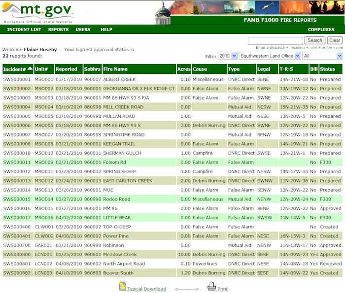
Incidents are started in the F300 Initial Fire Activity Application. The incidents show up in green in the F1000 Incident List as shown below by Folsom Rd, Rodeo Road and Little Bear Incidents.
Click on one of the green entries.

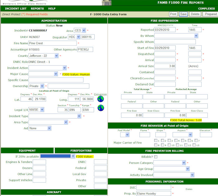
A Direct Protect Fire opened:
The incident will open into the correct template with as much information as is filled in the F300 already filled in here. Notice that the status is "New". This incident only becomes an F1000 incident by the first "save" or "prepared" where the status will change to "created".
The fields with a red star * are required; fields without the red star are optional. Information in Yellow is from the F300 but it doesn't have enough to choose the F1000 value and is giving you a hint.
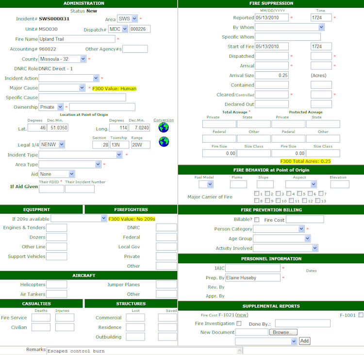
Required fields have a red * next to them.
| Required Fields | Optional Fields |
|
|
| Resources - at least one firefighter or aircraft unless it is a project cost share fire that we did not initial attack. In that case 209s are required | |
| Casualties - all | |
| Structures - all | |
|
|
| Fire Behavior - all required | Major Carrier of Fire - optional |
| Fire Prevention Billing - person category No-person for lightning |
|
| Personnel Information - All | |
| Remarks | |
Direct Protect Supplemental Documents |
|
| Required if | Optional |
| F-1001 Squad Record Of Incident Action - hard copy is required | F1021 Fire Investigation and Billing – short form |
Document Manager - New - Can append electronically as many documents as you need to portray the fire |
|
| Narrative | |
| Map required if fire is C class (>=10 acres)for westside or D class for eastside (>=100 acres or more) | |
| If a cost share fire, cost share agreement is required | |
| Zip Perimeter Fire required if fire is C class (>=10 acres)for westside or D class for eastsideor (>=100 acres or more) | |
| If 209s are available, at least a maximum resource 209 is required. Prefer also to have initial and final 209s. | |
| Other - any other document that aids in describing the incident | |
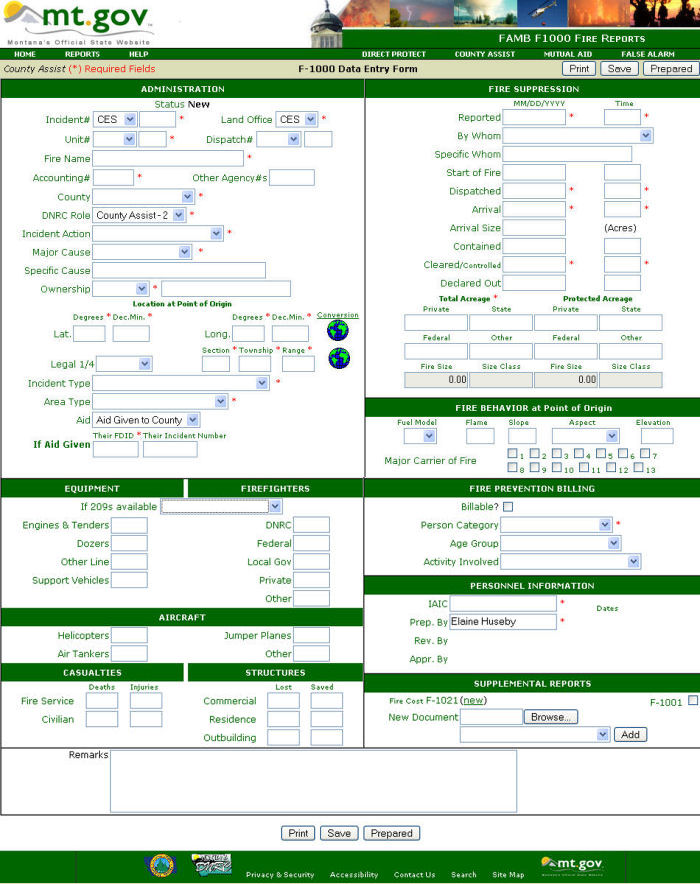
County assist fires are only those fires on private lands where the county commissioner has requested assistance and sent us a letter.
Two kinds of county assist scenarios:
View point for County Assist Fires:
A fire is a moving event. When we get involved in county assists it is past the initial attack stage. Our information on the fire report will reflect from the time we are called until the time we are done. We will focus on DNRC’s participation in the event. If fields are not filled in there will be a discussion of why in the narrative. All fire managers agreed to report or take notes on the fire sooner and provide narrative explanations of the real scenario in the narrative. For County Assist incidents we required fields to be non-mandatory to protect themselves and to portray an accurate picture of our involvement. They need the flexibility to explain things.
Fields optional for County Assists:
Maps discussion:
Why do we need a map? We need maps in the fire reports to document location, proximity, terrain, values or ownership. For a fire with no “boots on the ground”, providing a “point” map from NRIS is sufficient. But the fire manager will write in the narrative that they had no direct participation and this is all we can provide. The bureau would prefer a map for every fire > 10 acres. A point map for county assists will be sufficient with an explanation when our personnel did not actively participate in the fire management.
Times fields:
The times for “reported date/time” through “out date/time” will reflect from the time we are called until the time we are done. The start of incident time is very important in fire planning analysis. A new time field was created that is optional for “start of fire” on county assist fires to fill in if that is known.
Reported time and date will be when someone calls us i.e. when we were notified. “Reported date/time will be when DNRC became involved in the fire. We want the report to show accuracy of the actions we took.
Cleared time (Controlled time) will be the end of our involvement.
Arrival size: size when we get there or become aware of the fire.
| Required Fields | Optional Fields |
|
|
| Resources - at least one firefighter or aircraft unless it is a project cost share fire that we did not initial attack. In that case 209s are required | |
| Casualties - all | |
| Structures - all | |
|
|
| Fire Behavior | |
| Major Carrier of Fire - optional | |
| Fire Prevention Billing - person category No-person for lightning |
|
| Personnel Information - All | |
| Remarks or narrative required | |
County Assist Supplemental Documents |
|
| Required if | Optional |
Document Manager - New - Can append electronically as many documents as you need to portray the fire |
|
| Narrative or remarks required | |
| Letter from the County Commissioner is required | |
| Map required if fire is D class or greater(100 acres or more) | |
| Zip Perimeter Fire required if fire is C class (>=10 acres)for westside or D class for eastside (>=100 acres or more) | |
| If a cost share fire, cost share agreement is required | |
| If a suspicious fire, Fire Investigation Report | |
| If 209s are available, at least a maximum resource 209 is required. Prefer also to have initial and final 209s. | |
| Other - any other document that aids in describing the incident | |
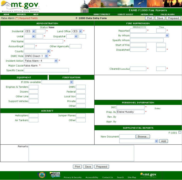
Required fields are marked in red *. Location is no longer required for false alarms. Neither hard copy documentation nor any supplemental are required.
| Required Fields | Optional Fields |
|
|
| Resources - at least one firefighter or aircraft | |
|
|
| Personnel Information - All | |
| Remarks | |
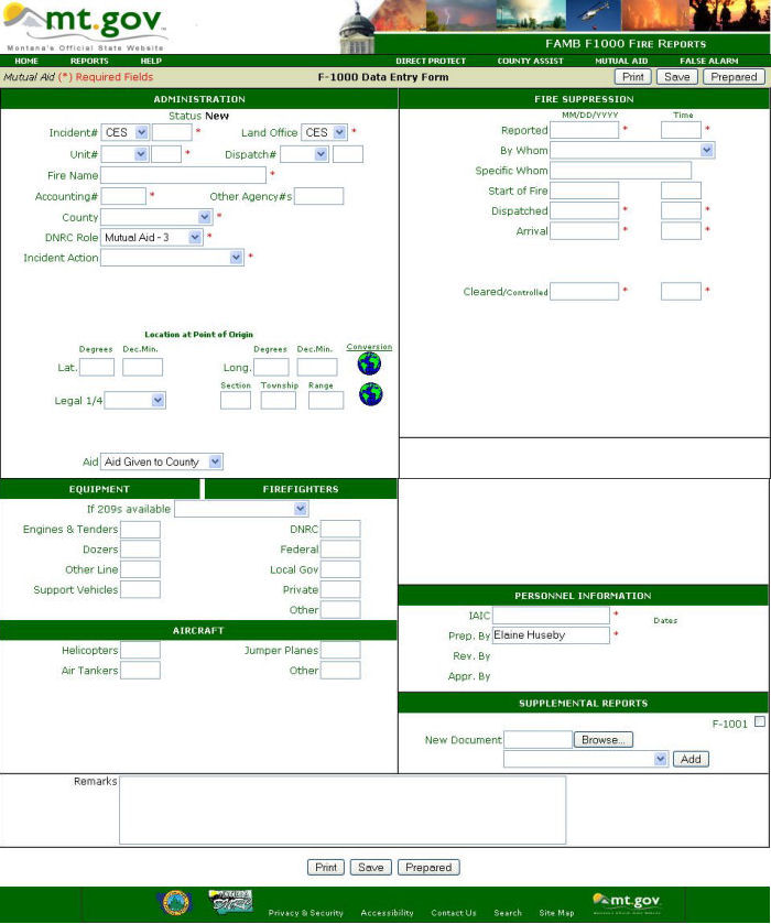
Required fields are marked in red *. Location is no longer required for Mutual Aids. Neither hard copy documentation nor any supplemental are required.
Federal assists must be reported now. But our mutual aid reporting has been streamlined. Our application allows entry of non-DNRC incident numbers.
| Required Fields | Optional Fields |
|
|
| Resources - at least one firefighter or aircraft | |
|
|
| Personnel Information - All | |
| Remarks | |
Printing the fire report should be done from the "Print" button on the F1000 form. ![]()
The bureau will NOT accept any printed reports that have not been approved.
This print is the most streamlined as it excludes the header pictures and footer from the form.
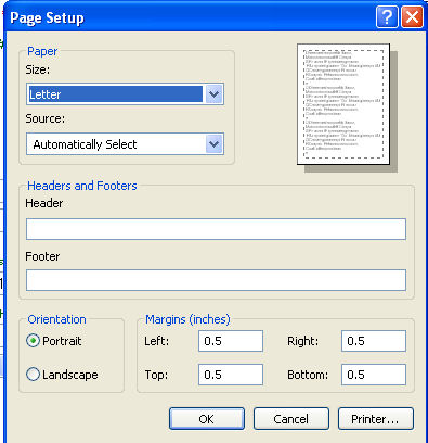 |
To get the most economical print page you want to also exclude the header and footer that Internet Explorer (IE) puts on the printed report. Go into the IE, file, page setup: Then erase everything in the header and footer text area. Click OK to save the changes. IE will remember these changes from now on. |
(field name = dispatch, text)
Dispatch IAN (Incident Action Number) is the internal number assigned by your local dispatch center. It is optional. If you opted to use it, the correct dispatch center initials will automatically be filled in and you fill in the 3-digit number you received from the dispatcher. If you opted not to use this field, the dispatch will be blank.
Dispatch Center |
|
BDC |
Billings Dispatch Center |
BZC |
Bozeman Dispatch Center |
DDC |
Dillon Dispatch Center |
KIC |
Flathead Dispatch Center |
GDC |
Great Falls Dispatch Center |
HDC |
Helena Dispatch Center |
KDC |
Kootenai Dispatch Center |
LEC |
Lewistown Dispatch Center |
MCC |
Miles City Dispatch Center |
MDC |
Missoula Dispatch Center |
PDC |
Plains Dispatch Center |
(field names = appr_status, text, 30)
(field name = firename, text, 30)
Enter the fire name as assigned by the Fire Unit. Refrain from using landowner names or names that may be in poor taste. Use names of natural or geographic features, such as rivers, canyons , lakes, or the name of an identifying feature near the fire area. Fires may also be listed with the same name but in combination with a number series. (Examples: Green Lake, Coyote Creek, Silver Mine #1, Silver Mine #2). Names of fires should be kept as short as possible.
Railroad fires should be named by railroad and the mile marker, like RR-MM213.
The words “fire”, "mutual aid" or “false alarm” SHOULD NOT be a part of the wildfire name.
(field name = fnumber, text, 9)
The combination of state designator, Area ID abbreviation, and 6-digit sequential number is the Incident Number for resource ordering purposes.
Example) MT-CES-000003. The state designator is common to all Montana incidents and is therefore not part of the form. Enter only the first three letters and sequential number. F1000 incident numbers are for:
| Area ID | Agency | Agency Office |
| CES | DNRC | Central Land Office |
| EAS | DNRC | Eastern Land Office |
| NES | DNRC | Northeastern Land Office |
| NWS | DNRC | Northwest Land Office |
| SOS | DNRC | Southern Land Office |
| SWS | DNRC | Southwest Land Office |
| BFA | BIA | Blackfeet Agency |
| CRA | BIA | Crow Agency |
| FBA | BIA | Fort Belknap Agency |
| FHA | BIA | Flathead Agency |
| FPA | BIA | Fort Peck Agency |
| NCA | BIA | Northern Cheyenne Agency |
| RBA | BIA | Rocky Boy's Agency |
| BUD | BLM | Butte Field Office |
| LED | BLM | Lewistown Field Office |
| MCD | BLM | Miles City Field Office |
| GNP | NPS | Glacier National Park |
| YNP | NPS | Yellowstone National Park |
| BDF | USFS | Beaverhead/Deerlodge National Forest |
| BRF | USFS | Bitterroot National Forest |
| CNF | USFS | Custer National Forest |
| FNF | USFS | Flathead National Forest |
| FWS | USFS | Fish & Wildlife Service |
| GNF | USFS | Gallatin National Forest |
| HNF | USFS | Helena National Forest |
| KNF | USFS | Kootenai National Forest |
| LCF | USFS | Lewis & Clark National Forest |
| LNF | USFS | Lolo National Forest |
(field name = unumber, text 6)
Each Land Office, Unit and Initial Attack Station is assigned a unique incident number and a unique unit number for each fire incident. All F1000 reportable incidents need to have a Unit number assigned to them.
Example) HLN 014
KAL |
Kalispell Unit |
DIL |
Dillon Unit |
PLN |
Plains Unit |
HLN |
Helena Unit |
SWN |
Swan Unit |
BOZ |
Bozeman Unit |
STW |
Stillwater Unit |
CON |
Conrad Unit |
LIB |
Libby Unit |
||
MSO |
Missoula Unit |
LCN |
Lincoln IA |
CLW |
Clearwater Unit |
GAR |
Garrison IA |
ANA |
Anaconda Unit |
For example, the following may be how a series of Land office fire numbers would be assigned to different fire incidents by the Southwestern Land office.
Incident Number |
Unit Office /IA Number |
State Accounting Number |
|
SWS-000001 |
MSO-001 |
56001 |
Direct protect fire |
SWS-000002 |
ANA-001 |
86001 |
County Assist fire |
LNF-000115 |
CLW-001 |
76998 |
Mutual Aid to Lolo National Forest |
FHA-000023 |
MSO-002 |
56010 |
Cost Share direct protect fire Started on Flathead Agency ground |
(field name = SABHRs, text, 5)
A 5-digit SABHRS number used to charge costs to. The Assigned DNRC Fire Numbers sheet is available on our website at: http://www.dnrc.mt.gov/forestry/Fire/Business/Documents/2008SABHRSFireNumbers.pdf
For specific instructions on the use of State Accounting, Budgeting and Human Resource System (SABHRS) numbers see the 300 - DNRC Incident Business Management Manual, Chapter 341 – Incident Cost Accounting section.
5Xxxx - Direct protection incidents
8Xxxx - County assist incidents
8X998 - Mutual aid to county or local government
7X998 – Mutual aid to federal agencies
The second digit relates to which land office the incident is in:
(field names = other_agency, text, 30)
Other agency numbers are accounting numbers from other agencies who gave aid on the fire, such as a USFS P number or the BLM incident number.
P1XXXX = USFS Region 1 cost number
PNXXXX = state agency
PDXXXX = BLM cost number
PAXXXX = Native American Agency cost number
PSXXXX = National Park Service cost number
(field names = county, text, 30)
Enter the county name. The Fire Department ID numbers (FDID) numbers were added to this table for the counties.
County # |
FDID # |
County |
County # |
FDID # |
County |
County # |
FDID # |
County |
01 |
01101 |
- Beaverhead |
19 |
19101 |
- Golden Valley |
38 |
38101 |
- Powder River |
02 |
02101 |
- Bighorn |
20 |
20101 |
- Granite |
39 |
39101 |
- Powell |
03 |
03101 |
- Blaine |
21 |
21101 |
- Hill |
40 |
40101 |
- Prairie |
04 |
04101 |
- Broadwater |
22 |
22101 |
- Jefferson |
41 |
41101 |
- Ravalli |
05 |
05101 |
- Carbon |
23 |
23101 |
- Judith Basin |
42 |
42101 |
- Richland |
06 |
06101 |
- Carter |
24 |
24101 |
- Lake |
43 |
43101 |
- Roosevelt |
07 |
07101 |
- Cascade |
25 |
25101 |
- Lewis & Clark |
44 |
44101 |
- Rosebud |
08 |
08101 |
- Choteau |
26 |
26101 |
- Liberty |
45 |
45101 |
- Sanders |
09 |
09101 |
- Custer |
27 |
27101 |
- Lincoln |
46 |
46101 |
- Sheridan |
10 |
10101 |
- Daniels |
28 |
28101 |
- Madison |
47 |
47101 |
- Silver Bow |
11 |
11101 |
- Dawson |
29 |
29101 |
- McCone |
48 |
48101 |
- Stillwater |
12 |
12101 |
- Deer Lodge |
30 |
30101 |
- Meagher |
49 |
49101 |
- Sweetgrass |
13 |
13101 |
- Fallon |
31 |
31101 |
- Mineral |
50 |
50101 |
- Teton |
14 |
14101 |
- Fergus |
32 |
32101 |
- Missoula |
51 |
51101 |
- Toole |
15 |
15101 |
- Flathead |
33 |
33101 |
- Musselshell |
52 |
52101 |
- Treasure |
16 |
16101 |
- Gallatin |
34 |
34101 |
- Park |
53 |
53101 |
- Valley |
17 |
17101 |
- Garfield |
35 |
35101 |
- Petroleum |
54 |
54101 |
- Wheatland |
18 |
18101 |
- Glacier |
36 |
36101 |
- Phillips |
55 |
55101 |
- Wibeaux |
37 |
37101 |
- Pondera |
56 |
56101 |
- Yellowstone |
(field names = role, text, 30)
Enter DNRC’s role in the fire.
1 - DNRC Direct
DNRC has primary responsibility because this fire occurred on land protected by DNRC as part of a forest fire district (or) this fire occurred on land covered by a DNRC fire protection affidavit (or) this fire poses a direct threat to lands protected by DNRC.
2 - County Assist
DNRC is providing assistance to a Cooperative County. A letter of assistance signed by the county commissioners must be submitted requesting DNRC to assist the county.
3 - Mutual Aid
Mutual aid is assistance provided by DNRC at no cost to the Protecting Agency. No hard copy or supporting documentation is needed for mutual aid incidents.
We may give mutual aid:
Typically mutual aid is aid to a Protecting Agency during the first operational period. Mutual aid may be:
(field names = action, text, 30)
A one digit number indicating the type of action or non-action taken by DNRC on this incident.
1 -Suppression
DNRC dispatched resources to put out the fire.
2 - Modified Suppression
DNRC dispatched resources to accomplish fire management objectives other than suppression. This includes containment, observation, etc.
3 - Non-Action
DNRC did not perform suppression or modified suppression activities. Wildfires, confirmed through observations, which go out by themselves or are extinguished by persons or factors other than the initial attack crews are classified as non-action. Examples include fires that were discovered after they had already gone out, or had been put out prior to our arrival on the scene.
4 - False Alarms
Choose false alarm if no fire was found or if what was found was a legal fire (campfire under control, debris burning with a permit, etc).
When the Incident is a false alarm, these fields are set automatically:
(field names = cause, text, 30)
A two digit code and descriptor designating the major cause category. General cause of fires usually are considered the general types of land-use activities responsible for fires.
0 |
False Alarm |
1 |
Lightning |
2 |
Campfire |
3 |
Smoking |
4 |
Debris Burning |
5 |
Arson |
6 |
Equipment |
7 |
Railroads |
8 |
Powerlines |
9 |
Miscellaneous or Unknown |
If the major cause selected is lightning, the Person Category is automatically filled in to “No Person”.
The definitions were created from the F100 manual – Terminology section and the NWCG Wildfire Prevention Handbook (PMS 450-1).
(field names = specific_cause, text, 50) - Optional
The specific cause of a fire is the activity or source of ignition that caused the fire. Specific cause tell us more information about the cause.
Examples:
DO NOT use specific cause on ARSON fires. Specific causes under Arson should be handled under the fire investigation.
Do not use specific cause for lightning fires or other fires where the Major Cause Category sufficiently identifies the fire cause.
(field names = ownership, text, 10 => contains dropdown text
specific_owner, text, 30) – is optional; only fill in if more specific information pertains to the fire report as a whole.
Choose the land ownership category at the point of origin.
Enter the name of the individual, company, agency, etc. that more specifically describes the owner.
Note: that both latitude/ longitude and the legal land description are required for direct protect and county assist fires. Location is optional for mutual aid incidents.
(field names = LatDeg, Numeric, 2.0
LatMin, Numeric, 2.4
LongDeg, Integer
LongMin, Numeric, 2.4)
Enter the latitude and longitude of the fire’s point of origin in degrees and decimal minutes.
The conversion box converts decimal degrees and degrees/minutes/seconds to degrees decimal minutes by simply entering the value you wish to convert, hitting the ">>" and clicking "use these values" to put the result back into the f1000 form latitude and longitude sections.
How to convert from Section /Township / Range to Degrees Decimal Minutes?
Enter the legal 1/4, Section /Township / Range.

Then click the NRIS globe. This will Bring you to an NRIS map with with a section to the right called "Map Center Coordinates". What we want to do is copy the decimal degrees latitude and longitude from the NRIS windows to the Lat Long Conversion Window. Under Decimal degrees click on the leftmost digit of the Lat, drag right to highlight the Latitude numbers.
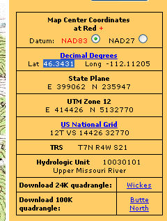
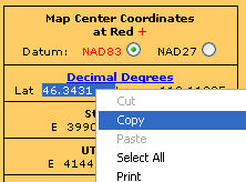
Right click and select "copy".
Now go back to the F1000 and click on "conversion to bring up the lat long conversion popup.

Click in the Lat. box of "Decimal Degrees", right click in the box and click on "paste".Then go back to the NRIS screen and complete for the copying and pasting the long value.
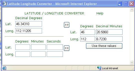
Click on the chevrons ">>" and the degrees deciMAl minutes fills in. Then click on "Use these values" and the pop-up box closes and the degrees decimal minutes fills in on the F1000 form.
A link to either the latitude or longitude has been added that will open an Internet window to an NRIS lookup location site to allow you to lookup via latitude and longitude or Section/Township/Range and you will get a map of that location with both lat/long and Section/Township/Range. We recommend that you use this to check your locations to see if they are mapped correctly. It is very easy to transpose numbers when entering location.
(field names =
legal_quarter, text, 4
section, integer
township, text, 4
range, text, 4)
NOTE: the leading ‘0’ is not wanted anymore, so T2N is what we want now, not T02N
Enter the legal land description of the fire’s point of origin to the nearest ¼ ¼ section.
Example: SESE S22 T2N R22W
Enter ¼ ¼ section: choose SESE from the dropdown.
Enter Section Number (2 digits): 22
Enter Township (2 digits & N or S): 2N
Enter Range ( 2 digits & E or W): 22W
Note: The ¼ ¼ is optional.
(field names = Incident, text, 50)
Choose the description that best describes the incident type. The incident type is the actual situation that personnel found on the scene when they arrived.
(field names = AreaType, text, 35)
This is a general description of the area where the wildland fire occurred. Choose the area type.
(field names = AID, text, 25)
Choose whether aid was given or received; this includes both free and reimbursable aid.
Valid values for Direct Protection are:
Valid value for Mutual Aid:
FDID number is no longer required for mutual aid incidents.
Valid value for County Assist is: Aid Given will be automatically filled in and will be 3 - Aid Given to County
(field names = AID_FDID, text, 5)
If aid is given on a county assist incident then the preferred entry is the FDID (Fire Department Identification number) # for the Fire Department whose jurisdiction responded.
If that is not known then the FDID for that county is required list of County FDID numbers .
(field names = report_dtm, smalldatetime - both the date and time are stored in the smalldatetime data type.
Enter the Date.
Enter the time when the fire was first reported to the DNRC office or dispatch center that is responsible for taking action. A new "Start_dtm" field was added primarily for county assists for the start of the fire when it is different from the date / time the fire was reported for the county assist. Filling out the reported date and time auto fills the start of fire date and time.
Enter in the form:
MM/DD/YYYY (i.e. 7/4/2004 or 7/4 or 7/4/07, the system will fill in the date to 7/4/2007.
Military time: (i.e. 0800)
(field names = whom, text, 30 – text in dropdown menu choice in by whom box
specific_whom, text, 30)
Enter the category of person reporting the fire followed by more “specific by whom” information if applicable.
(field names = start_dtm, smalldatetime (both the date and time are stored in the smalldatetime data type)
The reported date/time auto fills the start date/time. The actual start of the fire if known on a county assist should be filled in here.
Enter in the form:
MM/DD/YYYY (i.e. 07/04/1990 or 10/22/1990)
Military time: (i.e. 0800)
(field names = dispatch_dtm, smalldatetime (both the date and time are stored in the smalldatetime data type)
The date that DNRC authorized fire suppression resources were first dispatched to the fire, in the form:
Enter in the form:
MM/DD/YYYY (i.e. 7/4/2004 or 7/4 or 7/4/07, the system will fill in the date to 7/4/2007.
Military time: (i.e. 0800)
Note: When the dispatched date is filled in, the date will auto-fill in for the arrival, contained and controlled.
For false alarms and mutual aids, only the arrival and controlled date are auto-filled in. For those dates that are different, just overwrite the auto-filled in date.
(field names = arrival_dtm smalldatetime (both the date and time are stored in the smalldatetime data type)
The date and Time that the first DNRC authorized fire suppression resources arrived on the scene in the form:
Enter in the form:
MM/DD/YYYY (i.e. 7/4/2004 or 7/4 or 7/4/07, the system will fill in the date to 7/4/2007.
Military time: (i.e. 0800)
For false alarms, when the arrival time is filled-in, the controlled time is auto-filled in to equal the arrival time.
(field names = arrival_size, integer)
Record in acres (to the nearest tenth or hundredth of an acre as appropriate to the size class of the fire) at the time of arrival by the FIRST DNRC dispatched suppression resource. Spot fires less than one tenth acre are to be recorded to the nearest hundredth of an acre.
(field names = contain_dtm, smalldatetime (both the date and time are stored in the smalldatetime data type)
Enter in the form:
MM/DD/YYYY (i.e. 7/4/2004 or 7/4 or 7/4/07, the system will fill in the date to 7/4/2007.
Military time: (i.e. 0800)
(field names = control_dtm, smalldatetime (both the date and time are stored in the smalldatetime data type)
control _time, datetime)
Enter in the form:
MM/DD/YYYY (i.e. 7/4/2004 or 7/4 or 7/4/07, the system will fill in the date to 7/4/2007.
Military time: (i.e. 0800)
Controlled time can also referred to as “last unit cleared” time also.
(field names = control_dtm, smalldatetime (both the date and time are stored in the smalldatetime data type)
Enter in the form:
MM/DD/YYYY (i.e. 7/4/2004 or 7/4 or 7/4/07, the system will fill in the date to 7/4/2007.
Military time: (i.e. 0800)
(field names =
private_acre, numeric, 9.2 private acres
state_acre, numeric, 9.2 state acres
fed_acre, numeric, 9.2 federal acres
other_acre, numeric, 9.2 other acres
Fire size, numeric, 9.2 total fire size => calculated as total of private, state, federal and other fields.
Size class, text, 1 size class calculated field from ‘Fire size’ )
These fields are the actual size of the entire fire. Record in acres to the nearest tenth or hundredth of an acre as appropriate to size class. Spot fires are recorded to the nearest hundredth of an acre. LEAVE BLANK if no fire occurred in a category.
is a calculated field based on the total acreage. Spot fires must have a positive non-zero acreage so they will be calculated to be ‘A’ fires.
Fire Class
A - |
.01 |
acres |
to |
.25 acres |
B - |
.26 |
acres |
to |
9.9 acres |
C - |
10.0 |
acres |
to |
99.9 acres |
D - |
100.0 |
acres |
to |
299.9 acres |
E - |
300.0 |
acres |
to |
999.9 acres |
F - |
1000.0 |
acres |
to |
4999.9 acres |
G - |
5000.0 |
acres |
and larger |
|
Protected acreage is the ownership breakdown of the acres protected by DNRC. This acreage for a fire like a cost share fire may be different than the total fire acreage. We use protected acres for DNRC statistics on acreage burned.
Total acreage fields auto fill protected acres fields. But Protected acres fields can be modified.
(field names =
prot_private_acre, numeric, 9.2 private acres
prot_state_acre, numeric, 9.2 state acres
prot_fed_acre, numeric, 9.2 federal acres
prot_other_acre, numeric, 9.2 other acres
Protected Acres Fire size, numeric, 9.2 total fire size => calculated as total of private, state, federal and other protected acreage fields.
Size class, text, 1 size class calculated field from Protected ‘Fire size’ )
is a calculated field based on the protected acreage. Spot fires must have a positive non-zero acreage so they will be calculated to be ‘A’ fires.
(field names = fuel_model, integer)
An integer indicating the predominant fire behavior fuel model in the fire area. Utilize the following definitions to determine the proper fuel model:
GRASS GROUP
1 - Fire spread is governed by the fine herbaceous fuels that have cured or are nearly cured. Fires are surface fires that move rapidly through cured grass and associated material. Very little shrub or timber is present, generally less than one third of the area. Grasslands are represented along with stubble, and grass/shrub combinations that meet the above area constraint. Annual and perennial grasses are included in this fuel model.
2 - Fire spread is primarily through the fine herbaceous fuels, either curing or dead. These are surface fires where the herbaceous shrub or timber overstory, contribute to the fire intensity. Open shrub lands and pine stands , that cover one third or two thirds of the area may generally fit this model.
3 - Fires in this fuel are the most intense of the grass group and display high rates of spread under the influence of wind. Stands are tall, averaging about three feet, but considerable variation may occur. Approximately one third or more of the stand is considered dead or cured and maintains the fire. Wild or cultivated grains that haven't been harvested can be considered besides tall prairie and marshland grasses.
SHRUB GROUP
4 - Fire intensity and fast spreading fires involve the foliage and live and dead fine woody material in the crowns of a nearly continuous secondary overstory. Stands of mature alder or maple, six or more feet tall are typical candidates. Besides flammable foliage, there is dead woody material in the stand that significantly contributes to the fire intensity. There may be also a deep litter layer that confounds suppression efforts.
5 - Fire is generally carried in the surface fuels that are made up of litter cast by the shrubs and the grasses or shrubs in the understory. The fires are generally not very intense because surface fuel loads are light, the shrubs are young with little dead, and the foliage contain little volatile material. Shrubs are generally not tall but have nearly total coverage of the area. Young, green stands of alder and menzesia with no deadwood would qualify.
6 - Fires carry through the shrub layer where the foliage is more flammable than fuel model 5 but require moderate winds, greater than eight miles per hour at midflame height. Fire will drop to the ground at low wind speeds or openings in the stand. The shrubs are older, but not as tall as shrub types of model 4, nor do they contain as much fuel as model 4. A broad range of shrub conditions ore covered by this model.
7 - This fuel model is not applicable in our area of fire protection but coding is shown to provide continuity in numbering. Code numbers are used nationwide.
TIMBER GROUP
8 - Slow burning ground fires with low flame heights are generally the case, although the fire may encounter an occasional "jackpot" or heavy fuel concentration that can flare up. Only under severe weather conditions involving high temperatures, low humidities, and high winds do the fuels pose fire hazards. Closed canopy stands of short needle conifers or hardwoods that have leafed out support fire in the compact litter layer. This layer is mainly needles, leaves, and some twigs since little undergrowth is present in the stand. Representative conifer types are white pines, and lodgepole pine, spruce, firs, and larch.
9 - Fires run through the surface litter faster than model 8 and have higher flame height. Both long needle conifer and hardwood stands are typical. Closed stands of long needle pine like ponderosa are grouped in the model. Concentrations of dead/down woody material will contribute to possible torching out of trees, spotting, and crowning activity.
10 - The fires burn in the surface and ground fuels with greater fire intensity than the other timber litter models. Dead/down fuels include grater quantities of 3 inch or larger limb wood resulting from over maturity or natural events that create a large load of dead material on the forest floor. Crowning out, spotting, and torching of individual trees is more frequent in this fuel situation. Any forest type may be considered if heavy down materials are present; examples are insect or disease ridden stands, wind thrown stands, over mature situations with deadfall, and aged light thinning or partial cut slash.
LOGGING SLASH GROUP
11 - Fires are fairly active in the slash and herbaceous material intermixed with the slash. The spacing of the rather light fuel load, shading from overstory, or the aging of the fine fuels can contribute to limiting the fire potential. Light partial cuts or thinning operations in mixed conifer stands are considered. Clearcut operations generally produce more slash than represented here. The less than 3 inch material load is less than 12 tons per acre.
12 - Rapidly spreading fires with high intensities capable of generating fire brands can occur. When fire starts, it is generally sustained until a fuel break or change in fuels is encountered. The visual impression is dominated by slash and much of it is less the 3 inches in diameter. These fuels total less than 35 tons per acre and give the impression of well distributed fuels. Heavily thinned conifer stands, clearcuts, and medium or heavy partial cuts are represented.
13 - Fire is generally carried across the area by a continuous layer of slash. Large quantities of greater the 3 inch material are present. Fires spread quickly through the fine fuels and intensity builds up more slowly as the large fuels start burning. Active flaming is sustained for long periods and a wide variety of fire brands can be generated. Clearcuts and heavy partial cuts in mature and over mature stands are depicted where the slash load is dominated by the greater than 3 inch material. Situations where the slash still has "red" needles attached and the total load is lighter, more like model 12, can be represented because of the earlier higher intensity and quicker area involvement.
(field names = flame, integer)
A number indicating the maximum flame length IN FEET to occur on the ground, at the head of the fire, at initial attack. Round to the nearest foot.
(field names = slope, integer)
A number indicating the percent of slope at the point of origin. Record 0 for level ground.
(field names = aspect, text, 4)
A dropdown for the aspect at the point of origin.
L |
- Level |
||
N |
- North |
NW - |
Northwest |
S |
- South |
NE - |
Northeast |
E |
- East |
SW - |
Southwest |
W |
- West |
SE - |
Southeast |
(field name= elevation, integer)
A number indicating the elevation at the point of origin.
(Field name=Major_Carrier, varChar(30) This is a comma delimited list of fuel model numbers. See Fuel Model at point of origin for value details.
Major Carrier of Fire allows one to choose multiple fuel models as most representative of the fire as a whole. Especially in eastern Montana, it is common for larger fires to really have more than one fuel model be representative of the fire.
There must be at least one Firefighter or one Aircraft selected. An exception is "209s Appended" does not require any resources to also be checked.
For the resources section, if 209s are available:
(field name = resource), dropdown with the following 3 choices
Blank - the resources section shows the fires resources as it always has.
209s Appended
For the resources section, if a large fire that may have a team on it completes 209s we will use the "209s appended" as a supplemental documents instead of any resources in the resources section. If 209s are available you should get: initial 209, a 209 from the mid point where resources were at the maximum level, and the final 209.
IA with 209s appended
If this fire was also initial attacked by DNRC resources before it went beyond initial attack, choose the option "IA with 209s appended". The resources section will be filled in for the initial attack and 209s will be attached according to the previous paragraphs guidelines.
(field name=
eq_engine, integer Engines and tenders
eq_dozer, integer Dozers
eq_other, integer Other line building equipment
eq_support, integer Support vehicles)
Record the PEAK NUMBER of ground equipment used to take suppression action at the incident for each category. Note that this might not be the total number that went to the incident.
(field names=
ff_dnrc, integer DNRC employees or on DNRC payroll
ff_fed, integer Federal Employees
ff_local, integer Local government firefighters
ff_private, integer Private contractor firefighters
ff_other, integer Non-paid volunteers or others)
Record the PEAK NUMBER of firefighters, overhead, and support personnel at the incident. Note that this may not be the total number that went to the incident. Record in the following categories:
The numbers of aircraft used will include any received from other agencies.
(field names =
ac_helicopter, integer - Record the peak number of helicopters used on the incident.
ac_airtanker, integer - Record the peak number of air tankers used to drop retardant on the incident.
ac_smokejumper, integer - Record the peak number of smokejumper aircraft used on the incident.
ac_other, integer - Record the peak number of all other aircraft used on the incident. This includes planes used for detection, reconnaissance, infrared mapping and any other use. )
(field names =
fsc_death, integer - Write in the number of fire service personnel deaths that occurred on this incident.
fsc_injury, integer - Write in the number of fire service personnel injuries that occurred on this incident. Note: Injuries means all reportable injuries that were serious enough to be reported to workers compensation.
civ_death, integer - Write in the number of civilian deaths that occurred on this incident.
civ_injury, integer - Write in the number of civilian injuries that occurred on this incident.)
Structures Lost:
(field names =
sl_commercial, integer - Write in the number of commercial structures that were destroyed on this incident.
sl_home, integer - Write in the number of residences that were destroyed on this incident.
sl_outbuilding, integer - Write in the number of outbuildings that were destroyed on this incident.)
Structures Saved:
Note: In your opinion, were there any structures in imminent danger of being burned up that suppression efforts prevented. This is a subjective opinion and depends on the existing conditions at the time of the incident. A structure was saved when the incident commander believes that current or expected fire behavior had the potential for the fire to reach that structure.
Structures saved and structures threatened means the same thing.
(field names =
ss_commercial, integer - Write in the number of commercial structures that were saved by suppression efforts on this incident.
ss_homes, integer - Write in the number of residences that were saved by suppression efforts on this incident.
ss_outbuilding, integer - Write in the number of outbuilding that were saved by suppression efforts on this incident.
(field names = bill, text, 1)
All person caused fires are potentially billable fires. DNRC recognizes that some may not be billed for several reasons including: unknown billees, fire suppression agreements, administrative vs. suppression cost considerations , legal issues, etc. This field is to alert any other readers that this could be a billable fire. It is intended as a flag to take a closer look at this report. Checking billable does not mean that you are absolutely going to bill, only that it might be billable.
Note: use of the F-310 and fire cost itemization spreadsheet has been eliminated. For all non-SABHRS costs use the F-1021. The F1021 form is now included in the F1000 database for your convenience.
(field names= person, text, 20)
Choose the category that best identifies the residency of the person responsible for the fire ignition. ‘No Person’ is automatically filled in when the cause is set to lightning.
(field names= age, text, 20)
Choose the category indicating the age group of the person responsible for the fire start.
(field names= activity, text, 20)
Choose the PRIMARY activity of the person responsible for the fire start.
Categories listed may not be mutually exclusive. There is no "correct" response to the activity involved item. Record the activity that MOST CLOSELY in YOUR JUDGEMENT represents the individual's PRIMARY activity. If no category fits choose “Other/Unknown” and write in the activity if known.
(field names = IAIC, text, 30 - Enter the name of the initial attack incident commander (IAIC).
Note on Names:
Try to be consistent with the way you enter names, then you can search the historical database and find all fires where a particular person was IAIC for instance. We suggest that you enter the last name first, a comma, initial of first name, a comma and the agency abbreviation. This standard would facilitate searching for all fires with this IC name.
(field names=
appr_status, integer - 2-digit number for the approval status
status_name text(30) for the word that signifies the highest approval rating for this fire report with the following values:
(Electronic Signatures field names=
At this point in time (5/5/2008), one signature in ink is required on the hard copy and a hard copy with all hard copy attachments ia required to send in to the fire bureau. The land office fire program manager will determine for his people who that signaturee will be.
The status System for fire report approvals is:
We have requested that the F1000 Fire Report accept electronic signatures fully and for the electronic copy be the only one that needs submitting. Allowing this would require writing new administrative rules to accept this. That is not being done yet. In the meantime, hard copy of the fire report with hard copy of all attachments is still required to be sent in to the fire bureau with one signature of the approver or reviewer from your land office.
The eastern land offices that only have a fire program manager, the same person prepares, reviews and approves the report. Email notifications are suppressed when the next approver is the same as the reviewer, etc.
Check the appropriate box for any additional reports that are attached. Note: Please submit the original of any supplemental information with the F1000 report and retain a copy for your records.
(field names = sup_f1001, text, 1) - Squad Record Of Incident Action
This form is used by the Initial Attack Incident Commander to give accurate and complete fire situation reports, and assists in completing the F-1000 and the narrative report. There is no electronic F-1001. The box is checked to indicate that the hard copy F-1001 will be attached to the F1000 hard copy report.
See the 1800 Fire Forms Manual 1000-1100 for more information on the F-1001.
(field names = sup_f1021, text, 1) The 1021 form as an electronic form is available.
Fire Investigation and Billing – short form
This form was originally developed to facilitate rapid billing of minor human-caused fires with the hope that completing billing actions within a few weeks of the event would improve DNRC's’ ability to collect costs.
This form will now be used exclusively to list fire costs and will replace the F-310. Use this form for all non-SABHRS costs. The F-1021 has it's own help manual.
The document manager is the way the narrative and map are attached. The document manager allow you to insert as many supplemental documents as you need to the fire report. The supporting document types are:
Any piece of paper can be scanned on a scanner into a pdf file and attached via the document manager. Other valid file types will also be acceptable for scanned paper.
The reason for adding additional documents is two-fold:
The document manager looks like: The "remove" option is only there until the report is fully approved, then it disappears.
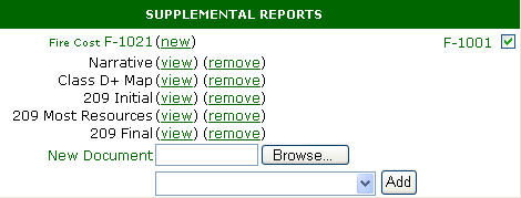
To add a document you "browse" to the file you want to add. Then in the "Add" dropdown, you select what kind of a document you are adding:
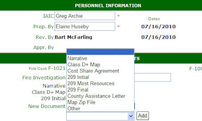
Then click on the "Add" button and the document you want is inserted and saved. This screen also shows the supplementals that are currently defined.
Other is the generic selection.
Submitting a fire narrative is mandatory for all fires. For false alarms and mutual aid incidents, filling in the “remarks” field is advised but both the remarks and the narrative are optional on false alarms and mutual aids. On small fires, a very brief description of the incident is sufficient.
Prepare the narrative as a Microsoft Word document.
A narrative is a factual account of what happened at the incident. Describe in your own words the sequence of events on this fire. Fire Narratives are "non-judgmental" and may include more or less detail depending on the scale of suppression activity and the narrative requirements specified by your land office. Do not critique the fire or an individual’s performance here.
On team fires (fires exceeding initial attack and where a team was called in to manage) the narrative should cover the initial attack if DNRC did the initial attack, transition to a team and give a short overview of the large fire suppression activity. Please list all the teams that were on the fire and the agency and location of the fire documentation package.
See the 1000 Fire Follow-up Manual for guidelines on Critiques and Narratives.
Direct Protection - A map is required for a class C or larger fire a map is required and / or a map upon request by the Fire & Aviation Management Bureau.
County Coop Protection - A map is required for a class D or larger fire a map is required and / or a map upon request by the Fire & Aviation Management Bureau.
Report of Preliminary Fire Investigation - This is a form used by fire investigators during the course of a preliminary fire investigation. It provides the necessary information for documentation of the fire and serves as a source document should a fire require further investigation.
See the 1800 Fire Forms Manual 1000-1100
The fire bureau wants to see the cost share agreement attached to the fire report as it will be very useful for fire billing and for audits.
We at the fire bureau want to see for county assist fires the letter of assistance from the county commissioners.
See the "If 209s Available section".
The document manager has a “Map Zip File” document type for fire perimeter files.
When you map the fire perimeter with a GPS, you can zip the folder with those perimeter files and add it to the F1000 fire report. For the Westside on fires C Class on 10 acres or more, save a GPS perimeter zipfile. Call Liz Hertz if you need help. (542-4222) On the eastside, Class D or bigger on 100 acres or more is the requirement for a map. If you did a fire perimeter, it is worth saving in the F1000.
If you take all the files that define the fire perimeter, save them in a folder and zip that folder, you can now attach the fire perimeter zip file via the document manager.
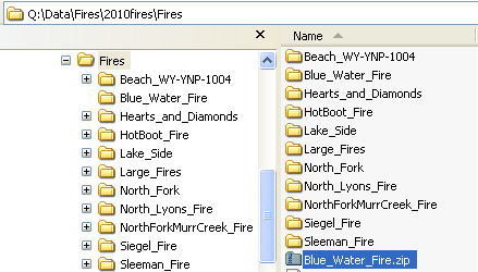
Transfer the fire perimeter files from the GPS to your computer. Find the folder where your perimeter files are. In this case we will zip the “Blue Water Fire” perimeter files. Right click on the “Blue_Water_Fire” folder in Windows Explorer or My Computer. In the actions pop-up you can perform, choose “Send To”, then choose “Compressed (Zipped) folder. This will create a zip file of all the files in Blue_Water_Fire folder.
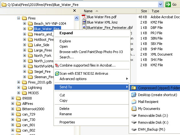
Then in the F1000 document manager for adding supplemental documents, click “browse” and find the zip file you just created: "Blue_Water_File.zip". Then choose “Map Zip File” from the add dropdown then click on “Add” button. The map perimeter file is now added to the F100.
